US Army Corps of Engineers
North Atlantic Division Website

base map 1. Acquisition and relocation 2. Building retrofit 3. Enhanced flood warning and evacuation planning 4. Land use management / zoning and flood insurance 5. Deployable floodwalls 6. Floodwalls 7. Levees 8. Seawalls 9. Revetments 10. Bulkheads 11. Storm surge barriers 12. Beach restoration 13. Beach restoration and breakwaters 14. Beach restoration and groins 15. Drainage improvements 16. Living shorelines 17. Overwash fans 18. Reefs 19. Submerged aquatic vegetation 20. Wetlands 1. Acquisition and Relocation 2. Building Retrofit 3. Enhanced Flood Warning and Evacuation Planning 4. Land Use Management / Zoning and Flood Insurance 5. Deployable Floodwalls 6. Floodwalls 7. Levees 8. Seawalls 9. Revetments 10. Bulkheads 11. Storm Surge Barriers 12. Beach Restoration 13. Beach Restoration and Breakwaters 14. Beach Restoration and Groins 15. Drainage Improvements 16. Living Shorelines 17. Overwash Fans 18. Reefs 19. Submerged Aquatic Vegetation 20. Wetlands

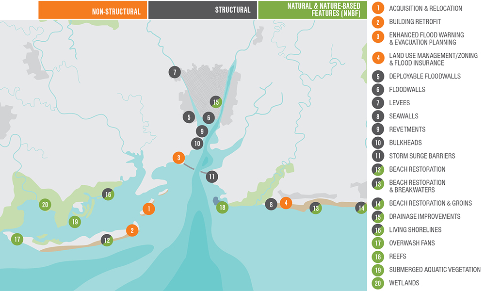
This map shows various coastal storm damage risk management strategies communities can use to adapt to anticipated base flood level change by 2100 (at a non-specific location). Although specific communities should consider a range of all possible solutions based on site-specific conditions, not all strategies to reduce coastal storm damage risk are structural solutions.

Non-structural: Acquisition and Relocation

  Non-structural:

Image #1: Acquisition and Relocation

  Acquisition and Relocation

  • Often considered a drastic approach to storm damage reduction, property acquisition and structure removal are usually associated with frequently damaged structures.
  • Implementation of other measures may be effective but if a structure is subject to repeated storm damage, this measure may represent the best alternative to eliminating risks to the property and residents.

Click here for a different view of the animation above.

Non-structural: Building Retrofit

  Non-structural:

Graphic #2: Building Retrofit

  Building Retrofit

  • A non-elevated structure in the flood zone is prone to flooding.
  • Building retrofit measures include elevation of a structure or possibly dry flood proofing of a structure.
  • Elevation of a structure is usually limited to smaller residential and commercial buildings.
  • Whether a  structure may be elevated depends on a number of factors, including the foundation type, wall type, size of structure, condition, etc.

Click here for a different view of the animation above.

Non-structural: Enhanced flood warning and evacuation planning

  Non-structural:

Graphic #3: Enhanced Flood Warning and Evacuation Planning

  Enhanced Flood   Warning and   Evacuation   Planning

  • Flood warning systems and evacuation planning are applicable to vulnerable areas.
  • Despite improved tracking and forecasting techniques, the uncertainty associated with the size of a storm, the path, or its duration necessitate that warnings be issued as early as possible.
  • Evacuation planning is imperative for areas with limited access, such as barrier islands, high density housing areas, elderly population centers, cultural resources, and areas with limited transportation options.

Click here for a different view of the animation above.

Non-structural: Land use management / zoning and flood insurance

   Non-structural:

Graphic #4: Land Use  Management /  Zoning and  Flood  Insurance

  Land Use Management / Zoning and Flood Insurance

  • Communities participating in the National Flood Insurance Program are proactive in promoting floodplain management and flood risk awareness.

Click here for a different view of the animation above.

Structural: Deployable Floodwalls

   Structural:

Graphic 5: Deployable Floodwalls

   Deployable Floodwalls

  • Rapid Deployment Floodwalls are structures that are temporarily erected along the banks of a river or estuary, or in the path of floodwaters.
  • Rapid Deployment Floodwalls also prevent water from reaching the area behind the structure and are usually used in locations where space is limited.

Click here for a different view of the animation above.

Structural: Floodwalls

   Structural:

Graphic #6: Floodwalls

   Floodwalls

  • Floodwalls are structures used to prevent flooding and to protect relatively small areas or areas with limited space for large flood protection measures.
  • Floodwalls are most frequently used in urban and industrial areas.

Click here for a different view of the animation to the right.

Structural: Levees

  Structural:

Graphic #7: Levees

  Levees

  • Levees and dikes are embankments constructed along a waterfront to prevent flooding in relatively large areas for high levels of flood risk.
  • If a levee or dike is located in an erosive shoreline environment, revetments may be needed on the waterfront side for more protection from erosion 


Click here for a different view of the animation to the right.

Structural: Seawalls

   Structural:

Graphic #8: Seawalls

   Seawalls

  • Seawalls, are typically massive structures whose primary purpose is interception of waves and reduction of wave-induced overtopping and flooding.
  • Note that under this definition seawalls do not include structures with the principal function of reducing flood risk to low-lying coastal areas.
  • In those cases a high, impermeable, armored structure known as a sea dike is typically required to prevent coastal flooding.


Click here for a different view of the animation to the right.

Structural: Revetments

   Structural:

Graphic #9: Revetments

   Revetments

  • Revetments are onshore structures with the principal function of protecting the shoreline from erosion.
  • Revetments typically consist of a cladding of stone, concrete, or asphalt to armor sloping natural shoreline profiles.


Click here for a different view of the animation to the right.

Structural: Bulkheads

   Structural:

Graphic #10: Bulkheads

   Bulkheads

  • Bulkheads primarily retain soil and experience little to no wave action. 


Click here for a different view of the animation to the right.

Structural: Storm Surge Barriers

   Structural:

Graphic #11: Storm Surge Barriers 

Storm Surge Barriers

  • Storm surge barriers reduce risk to estuaries against storm surge flooding and waves.
  • In most cases the barrier consists of a series of movable gates that normally stay open under normal conditions to let the flow pass but are closed when storm surges are expected to exceed a certain level.
  • Storm surge barriers are often chosen as a preferred alternative to close off estuaries and reduce the required length of flood protection measures behind the barriers.
  • Storm surge barriers are typically opened during normal conditions to allow for navigation and saltwater exchange with the estuarine areas landward of the barrier. 

Click here for a different view of the animation above.

Structural / Natural and nature-based features: Beach Restoration

   Structural / Natural and Nature-Based Features:

Graphic #12: Beach Restoration

   Beach Restoration

  •  Relatively narrow beach and low dunes fronting a typical beachfront development.
  • A beach with beach fill has a wide berm and high, vegetated dunes.


Click here for a different view of the animation to the right.

Structural / Natural and nature-based features: Beach Restoration and Breakwaters

   Structural / Natural and nature-based features:

Graphic #13: Beach Restoration and Breakwaters

   Beach Restoration and Breakwaters

  • Narrow beach and low dunes fronting a typical beachfront development.
  • Wide and narrow beach with breakwaters in front of beach, less wave exposure.
  • Breakwaters reduce the amount of wave exposure.

Click here for a different view of the animation above.

Structural / Natural and nature-based features: Beach Restoration and Groins

   Structural / Natural and nature-based features:

Graphic #14: Beach Restoration and Groins


  Beach Restoration and Groins

  • On some coastlines, there is more sand leaving the area via longshore sediment transport than there is sand arriving to replace it. Such beaches are eroding and are typically very narrow.
  • Groins are structures that extend perpendicularly from the shoreline.
  • Groins are usually built to stabilize a stretch of natural or artificially nourished beach against erosion that is due primarily to a net longshore loss of beach material.
  • The effect of a single groin is accretion of beach material on the updrift side and erosion on the downdrift side.

Click here for a different view of the animation above.

Structural / Natural and nature-based features: Drainage Improvements

   Structural / Natural and nature-based features:

Graphic #15: Drainage Improvements

   Drainage Improvements

  • A drainage system can carry water away via conveyance systems and, during times of high water, may store water until it can be carried away in storage facilities.
  • Conveyance systems utilize measures such as pump stations, culverts, drains, and inlets to remove water from a site quickly and send it to larger streams.
  • Storage facilities are used to store excess water until the storm or flood event has ended.


Click here for a different view of the animation to the right.

Structural / Natural and nature-based features: Living Shorelines

   Structural / Natural and nature-based features:

Graphic #16: Living Shorelines

  Living Shorelines

  • Open and exposed shorelines are prone to erosion due to waves.
  • Living shorelines are essentially tidal wetlands constructed along a shoreline to reduce coastal erosion.
  • Living shorelines maintain dynamic shoreline processes, and provide habitat for organisms such as fish, crabs and turtles.
  • An essential component of a living shoreline is constructing a rock structure (breakwater/sill) offshore and parallel to the shoreline to serve as protection from wave energy that would impact the wetland area and cause erosion and damage or removal of the tidal plants.

Click here for a different view of the animation above.

Natural and nature-based features: Overwash Fans

   Natural and nature-based features:

Graphic #17: Overwash Fans

   Overwash Fans

  • Overwash fans are a component of the sediment budget of barrier islands.
  • Overwash fans are believed to be a relevant process in the rollover or retreat mechanism of some coastal barriers in response to sea level rise.

Click here for a different view of the animation above.

Natural and nature-based features: Reefs

   Natural and nature-based features:

Graphic #18: Reefs

   Reefs

  • The development of artificial reefs in bays provides a means to reestablish and enhance reef communities.
  • Artificial reefs provide shoreline erosion protection.
  • Artificial reefs are established for various reasons, amongst others:
    • restore degraded or damaged natural reefs.
    • Provide three dimensional habitat structure above the bottom.
    • Provide fishing and scuba diving opportunities.

Click here for a different view of the animation above.

Natural and nature-based features: Submerged Aquatic Vegetation

  Natural and nature-based features:

Graphic #19, Submerged Aquatic Vegetation

  Submerged aquatic vegetation

  • Submerged Aquatic Vegetation performs many important functions, including:
    • Wave attenuation and sediment stabilization,
    • Water quality improvement,
    • Primary production,
    • Food web support for secondary consumers, and
    • Provision of critical nursery and refuge habitat for fisheries species.

Click here for a different view of the animation above.

Natural and nature-based features: Wetlands

Nature and nature-based features:

Graphic #20, Wetlands

    Wetlands

  • The dense vegetation and shallow waters within wetlands can slow the advance of storm surge somewhat and slightly reduce the surge landward of the wetland or slow its arrival time.
  • Wetlands can also dissipate wave energy; potentially reducing the amount of destructive wave energy propagating on top of the surge, though evidence suggests that slow-moving storms and those with long periods of high winds that produce marsh flooding can reduce this benefit.

Click here for a different view of the animation above.